Sunday, June 20, 2010

Eugene Jun 13-19

Stopped at Eugene, OR for some routine maintenance (our RV was made here; they have some great techs here). Enjoyed learning more about our coach from people who know what they are doing.

Got a chance to play some tennis with the local USTA Eugene team going to sectionals; good players (primarily indoor hard courts). Also played with Buzz Summers, long time coach of U of Oregon's tennis team; at 73, he is still a wonderful player (someone told me that he was ranked as high at #5 nationally about 10 years ago). Oregon is very organic, very progressive and very independent. Eugene has a great farmer's market downtown; all these people with advanced degrees selling their organic fruits and vegetables. Can they make enough to send their kids to college?
"Where have all the flowers (flower children) gone?" "Gone to Eugene, every one." Felt like we were in a time warp from the 60's. Hippy Diffy Weatherman definitely here. Everything is Peace, Love and Full Self Expression. Woodstock is here!

Got a chance to have dinner with Marsha and Flavio, good Pa. friends (did not get a good picture). Just like old times, great. Met in Corvallis, home of Oregon State University.
Visited Salem, Oregon's capital. Nice tour of the Capitol building. Both House and Senate work for six continuous months then are off for eighteen months. People don't want their reps to be professional politicians. Hmm, maybe they have something there. Below, Marlene with our tour guide, David Schmidt; excellent docent.


Also did a tour of the Asahel Bush house; built in late 1800's. Sinks in the women's bedrooms had faucets that they pinched rather than turned, so they would not build up unsightly masculine muscles on their wrists.
Near Eugene we visited a few wineries; below nice views of the King Estate, an excellent restaurant plus good wines.


Nice shot of some poppys.


Saturday, June 12, 2010

Coos Bay/Oregon Coast Jun 9-12

Coos Bay, on the central Oregon coast; we stayed at an RV park next to the Mill Casino (total winnings $13). Below is an eastward view out of our window looking over the Bay (Ocean is behind us). Took a drive down the coast; didn't know we were entering "The Tsunami Zone".
The coast is beautiful, mostly rocky, much like Highway 1 (Big Sur) in CA. Below some shots we took along the way.

Also included a video (noisy) at the end of this entry on "Cook's Chasm", interesting mix of the sea on hollowed rocks with blow holes and other interesting effects.


Just north of us on the coast is a 40 mile long strip known as Oregon National Dunes Recreational Area; with huge (we're talking up to 300+ feet high) sand dunes that is open to the public for atv fun, sand boarding, motorbiking. There were several rental shops near us and I decided to go for a ride (never been on an atv). Below I am all decked out, ready to ride.

The dunes were pretty wide open, weather good, but it took some time for me to get used to the atv. I did not tackle the 200 ft hills (fairly steep) but I did manage to get up some 100 footers. I tried to take some pictures showing some other riders; difficult even when I was resting. Double click on the picture below; another rider taking one of the bigger hills. Believe me, it looks a lot steeper in real life. Had a great time; could have used a buddy to ride with.

Finally, what is the story with all the drive thru coffee/expresso kiosks around here? Can they all be making money? They are all over Oregon. Below two of several just in the small town of Coos Bay.


Tuesday, June 8, 2010

Ashland, OR Jun 4-8

Ashland, Oregon, home to the Shakespeare Festival and So. Oregon University. Nice town. First stop, Crater Lake.

Crater Lake was formed when Mt. Mazama (one of the volatile Cascade Mountains) had a massive eruption (40 times the more recent Mt. St. Helens (another Cascade Mt.) eruption) 8,000 years ago. The result of all the magma released resulted in a collapse of the remaining mountain which dropped about 5,000 ft. The drop created a 6 mile wide crater, which is now a lake, not fed by any stream. The lake is filled by rain and winter snows, approximately 1,600 ft. deep, the deepest in the US and one of the deepest in the world. Because it is so deep, all the colors of visible light have been absorbed except blue, resulting in deep, deep blue water. Unfortunately, the area gets 40 ft of snow/year and the national park rangers spend 4 mo/year clearing the snow, starting in May. When we got there, only a small portion of the rim was open, with 6-10 feet of snow piled high next to the road. It was about 40 degrees with a strong, cold wind. I accidently hit the video button on the camera vs. picture; the video is at the bottom of this entry.

On the way up there we went by the Rogue River; below a more peaceful part of it; guys fishing.

Other parts were roaring, two videos at the bottom of this entry; it was really cooking. Went into Ashland, visited a market where it seemed everything was organic. Everything we got was excellent, arugula, olive oil, fresh baked bread. Below one of the local's tents. Why can't we get stuff like this in HH?

Great shot of this young lady playing the cello and singing in front of her family's goat dairy tent. Double click on it to enlarge it.


Also went to the lava beds, home of the largest collection of lava tubes (caves left after the lava left the center of the tunnels). Fun for exploring, caves/tubes everywhere.


Thursday, June 3, 2010

Redding, CA May 28-Jun 2

Delightful Redding, in northern CA. Below is a view from our RV front window; we were overlooking the Sacramento River. Very pleasant. Appropriately enough, on Memorial Day Sunday, at the foot of snow covered, 10,000 ft. Mt. Shasta, we happened upon the Living Memorial Sculpture Garden, a sculpture memorial dedicated to veterans of all conflicts. It turned out to be quite moving. Below is a Navy Commander giving a Memorial Day tribute (significant local audience) in front of a wall of remembrance of veterans from the local area.
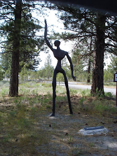
As it happened, an ex-Marine, Dennis Smith, working through post traumatic difficulties from the VietNam war, created (in iron) a number of sculptures dedicated to different aspects of veterans of America's wars. Both Marlene and I were very moved by the simplicity of the sculptures, their elegance and their setting in Klamath National Forest. The entry plaque reads "A place to remember where we have been: A place to remember what we've been through: A place to remember those faces so well of friends and loved ones: A place to remember, A place to mend. To bring our minds back to reality again. To help see our futures so we can move on."

Above, one of my favorites, dedicated to "The Korean War Veteran"; A soldier sits, head in hand, remembering. "While Vietnam Memorials were popping up like mushrooms, who remembered the Korean War Vet? We did. This one's for you, my spiritual uncles......Semper Fi."


Above, "The Peaceful Warrior", a tall figure, arm raised. "There must be those who, loving peace, will fight against agression to preserve that peace. There is no contradiction in this. As long as such warriors are needed, The Peaceful Warrior honors those who step forward when asked to do so."
Wonderful experience, great story.


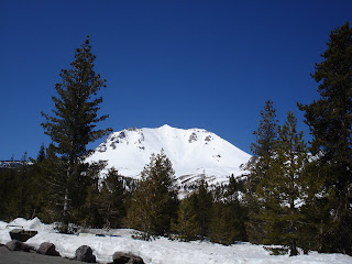
This area is a very active geographic area. Above is Lassen Peak, one of the recently active (1915) line of Cascade volcanos (includes Mt. St. Helens). Due to heavy winter snows, we could not look into the bubbling pools of hot mud or into the dome of Lassen, formed during the massive eruption in 1915. Below, Marlene next to the remaining snow, as far as they would let us go. A father and his teenage daughter were there, getting ready to walk halfway up the moutain in order to snowboard down (said it would take them about 2-3 hours to get up there).


Below is Burney Falls state park; I tried to do a video; messed it up; can't seem to get enough of these waterfalls. You can walk right down to the foot of the falls. Park was packed for the weekend.

Below, Mt. Shasta, over 10,000ft high, still has a lot of snow as of the end of May. Snow melts and flows into Shasta Lake, developed when Shasta dam was created in 1945. Beautiful area.

Interesting story behind the Shasta Dam, below. Built in 1938-1945, it is the second largest dam in the US (in amount of material used). Extra thick with complex expansion joints to withstand an 8.5 earthquake, the dam is in great shape. It controls flooding in the Redding area, provides measured water for all the central California agricultural areas, and produces electricity. The gentleman who was the genius behind building the dam, Frank Crowe, developed an efficient, but very precise way to build the dam so that they finished 2 years (yes, 2 years) ahead of schedule, and this was during the WWII years when concrete was more difficult to come by than original forecast. Dam is in great shape; Crowe did a magnificent job.

Below a diagram of Crowe's construction layout. The square at the top of the diagram is where the main tower was sent buckets of concrete down a zip line to a spot over where it was to be poured. The curved lines were railroad tracks so that the zip line could be adjusted precisely to drop the concrete exactly over the block of area they were filling. Other dams had to re-assemble their concrete deposit methods everytime they moved to a different part of the dam, resulting in longer time requirement. With 6.5 million cubic yards of concrete, you can see how this innovation could offer dramatic savings. Did all their calculations with slide rule technology, not easy.


Finally, went into town, visited the Turtle Creek Exposition Park, home of their noted Sundial Bridge, a cantilever spar cable-stayed bridge, designed by Santiago Calatreva, finished in 2004. Pretty neat.


Below, Marlene took a shot of some unusual flowers at the Turtle Creek gardens.